

A property survey can mean pacing around a garden, checking a pasture boundary, or collecting coordinates that need to hold up in a professional mapping workflow. The wrong handheld GPS makes a simple job frustrating, especially when its screen is hard to read outdoors or its accuracy claims do not match the work.
The Best GPS for Surveying Property depends on the level of precision you need. Some of these units measure area, distance, and slope without saving usable map data. Others are full RTK receivers that pair with a phone or survey pole for centimeter-level positioning.
GEO-Measure RTK GNSS is our top pick for serious property measurement, while the ZL190PLUS is the more approachable choice for straightforward land, area, and slope work. The rest range from compact area meters to a complete rover and base setup, plus one surveying pole accessory.
Comparison table
| # | Product | Award | Accuracy or positioning | Screen or software | Battery or construction | Best for |
|---|---|---|---|---|---|---|
| 1 | GEO-Measure RTK GNSS | Best overall | 8 mm + 1 ppm horizontal, 15 mm + 1 ppm vertical | iOS and Android app, CSV, KML, GeoJSON, GPX export | 24 hours, IP67, 2 m shock resistance | Professional property mapping |
| 2 | ZL190PLUS | Best handheld land meter | Area error under 0.002 acres, distance error under 5 feet | 3.2-inch, 240 x 320 color screen, seven modes | 48 hours, IP65 | General property and acreage work |
| 3 | ZL660 | Best long-battery alternative | Area error under 0.002 acres, distance error under 5 feet | 3.2-inch, 240 x 320 color screen, seven modes | 48 hours, rugged waterproof and dustproof design | Long field days |
| 4 | SMAJAYU SMA26 Plus | Best complete RTK kit | 3 mm to 8 mm with rover and base | Survey software, IMU tilt compensation, PPK and PPP | IP67, 5 to 10 km UHF range | Construction and advanced surveying |
| 5 | Heltec Land Meter | Best for slopes | ±1% for areas over 2, 000 square meters, ±2 m positioning | Real-time graphics, USB export, slope and mountain modes | 18 hours, IP65, 112 g | Hilly land and trails |
| 6 | BEVA Handheld Survey GPS | Best simple interface | ±0.002 acres | 3.2-inch anti-glare TFT display, three area modes | Rubberized, water and dust resistant | Basic outdoor measurement |
| 7 | ZL180 | Best compact area meter | Area error in 0.003 acres | 2.4-inch backlit FSTN display, four modes | 180 g, compact grooved grip | Gardens and open property |
| 8 | EM90 Handheld Survey Unit | Best for stored records | Area error in 0.003 acres | Backlit display, live track, up to 50 records | 3, 500 mAh battery, lanyard | Repeated area measurements |
| 9 | LiebeWH GPS Area Meter | Best live measurement view | High-sensitivity outdoor positioning | 2.4-inch LCD, area, length, and track shown together | 5.5 Wh battery | Lawn and farm planning |
| 10 | AdirPro Rover Rod | Best rover-pole accessory | Supports mounted GNSS equipment | Standard 5/8-11 mounting thread | Two-piece aluminum, 2 m, 2.2 lb | Holding an RTK receiver |
1. GEO-Measure RTK GNSS: Best Overall

Pros
- Centimeter-level RTK positioning
- Works with iOS and Android phones
- Exports CSV, KML, GeoJSON, and GPX files
- IP67 protection and 24-hour battery
- Includes a 1-year RTK correction service
Cons
- Requires a phone and app for the full workflow
- Its professional features demand more setup than a simple area meter
- RTK performance depends on correction connectivity and sky conditions
Best for: property professionals who need mapped points and repeatable survey data rather than a rough acreage estimate.
The GEO-Measure RTK GNSS is the one that changes the meaning of “surveying” in this group. It is not just a handheld land meter that estimates the size of an area as you walk. It is a rover receiver designed to collect points, paths, and project data through an iOS or Android phone. For property lines, construction layouts, GIS work, and stakeout tasks, that distinction matters more than a larger built-in screen.
Its multi-frequency GNSS hardware tracks GPS, GLONASS, Galileo, and BeiDou on L1, L2, and L5 bands, with up to 1, 040 channels. The listed accuracy is 8 mm plus 1 ppm horizontally and 15 mm plus 1 ppm vertically when using RTK corrections. That is a completely different class of result from the approximate area and distance figures attached to the ZL190PLUS or ZL660. The receiver also works with NTRIP or CORS connections, and its included GEODNET service is intended to provide corrections without setting up a local base station.
The phone connection is a practical advantage. The GEO-MEASURE app handles satellite monitoring, point collection, path collection, project management, and exports to CSV, KML, GeoJSON, and GPX. Those formats make the GEO-Measure far more useful after leaving the field. The receiver has a standard 5/8-11 thread, so it can mount to a survey pole such as the AdirPro Rover Rod, though the pole is not included with this receiver.
The tradeoff is complexity. A landowner who only wants to estimate a lawn or pasture may find the ZL180 easier to understand, and the ZL190PLUS has a self-contained screen and measurement modes. The GEO-Measure also depends on a phone, an app, and a correction connection for its headline accuracy. Its 6, 800 mAh battery can run for up to 24 hours, while IP67 protection and 2 m shock resistance make it suited to rougher work. It is the right choice for buyers who need actual field data, not merely a number on a display.
2. ZL190PLUS: Best Handheld Land Meter
Pros
- Seven measurement modes
- Large sunlight-readable color display
- Supports six satellite systems
- Stores coordinate points
- Up to 48 hours of continuous use
Cons
- Does not provide navigation or a map
- Saved coordinates cannot be edited
- Must be held horizontally during measurement
Best for: landowners who want one self-contained device for area, distance, slope, height, and coordinate recording.
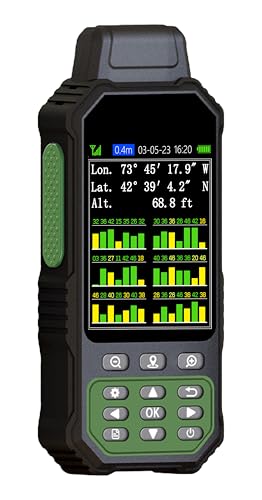
The ZL190PLUS is the most balanced handheld land meter here. It avoids the phone and correction-network workflow of the GEO-Measure RTK GNSS, but it gives you more to work with than a basic area-only device. Its seven modes cover regular and irregular area measurement, straight and curved distances, height, slope, and coordinate saving. That range makes it a sensible fit for a property owner who may measure a field one day and check a driveway or hillside the next.
The 3.2-inch color screen has a 240 x 320 pixel display and is described as sunlight readable. That is a meaningful advantage over the smaller 2.4-inch displays on the ZL180, EM90, and LiebeWH unit. You still need an unobstructed outdoor sky before taking a reading, and the device should be held horizontally. Its published guidance recommends areas above 0.04 acres and distances above 328 feet, with larger measurements tending to reduce the relative error.
Six satellite systems are supported: GPS, BeiDou, Galileo, GLONASS, NAVIC, and QZSS. The stated area error is under 0.002 acres and distance error is under 5 feet. Those figures make the ZL190PLUS useful for planning and estimating, but they should not be confused with the centimeter-level RTK output of the GEO-Measure or SMAJAYU SMA26 Plus. The ZL190PLUS does not have a map and cannot be used for navigation.
A 4, 000 mAh rechargeable battery is rated for up to 48 hours of continuous use, and the IP65 design adds protection against dust and water exposure. It is also light at about 0.49 pounds. The main limitation is data handling: the unit can save current coordinate points, but those points cannot be modified. For a straightforward property survey that ends with measurements recorded in the field, it is the handheld we would choose.
3. ZL660: Best Long-Battery Alternative

Pros
- Up to 48 hours of battery life
- Six satellite systems
- Seven one-key measurement modes
- Bright 3.2-inch color screen
- Compact contoured grip and lanyard
Cons
- No navigation or map support
- Saved coordinates cannot be edited
- Accuracy depends on open-sky conditions and proper handling
Best for: users who want the ZL190PLUS feature set with a similarly long-running handheld design.
The ZL660 is a close companion to the ZL190PLUS, with nearly the same core measurement brief and a slightly different physical presentation. It is aimed at people who need a clear handheld tool for large property assessments, farmland, pastures, and general land work. The contoured grip and included lanyard are small details, but they matter when the device is being carried and held for repeated readings.
Its seven modes include area measurement, straight and curved distance, height, slope, and coordinate saving. One-key access is useful in the field because it reduces menu hunting. The six-system GNSS support covers GPS, BeiDou, Galileo, GLONASS, NAVIC, and QZSS. The listed performance is an area error under 0.002 acres and a distance error under 5 feet, provided the unit has settled on a signal and is held horizontally.
The 3.2-inch color display runs at 240 x 320 pixels and is designed to remain readable in bright sunlight. That gives it the same practical screen advantage as the ZL190PLUS over the smaller-screen models. Its built-in 4, 000 mAh lithium battery is rated for up to 48 hours of surveying operation, which is useful for multi-day work where charging access is limited. IP65 protection supports its rugged field positioning, although no specific immersion protection is listed.
The ZL660 does not solve the central limitation of this class of device. It cannot navigate, display a map, or edit saved coordinates, and it is not an RTK receiver. The GEO-Measure is the obvious step up for mapped, centimeter-level work, while the ZL180 is smaller and simpler. Choose the ZL660 when long battery life and a readable screen matter more than phone-based data export.
4. SMAJAYU SMA26 Plus: Best Complete RTK Kit

Pros
- Includes rover and base equipment
- IMU tilt compensation
- PPK and PPP support
- 5 to 10 km UHF communication range in ideal conditions
- IP67 waterproof design
Cons
- More equipment than most property owners need
- Setup and survey software require specialist knowledge
- The stated UHF range depends on unobstructed conditions
Best for: surveyors, contractors, and construction teams that need a full rover and base workflow.
The SMAJAYU SMA26 Plus is the most elaborate system in this roundup. It is not a pocket GPS for casually estimating a backyard. The package is built around rover and base operation, with survey software, a tripod, pole, and tribrach listed in the product title. That makes it a more complete starting point for teams already familiar with GNSS surveying equipment.
Its strongest feature is the combination of RTK positioning and tilt compensation. The unit is described as supporting measurement with the receiver tilted from 30 to 60 degrees while maintaining centimeter-level accuracy. That can save time when a pole cannot be kept perfectly vertical at every point. The product also lists PPK and PPP technology, along with compatibility with several radio protocols, including LoRa, Transparent, Trimtalk, TRMMARK3, SOUTH, and SATEL standards.
The claimed rover and base accuracy is 3 mm to 8 mm, and the UHF link is specified for 5 to 10 km under ideal conditions without obstacles or interference. An IP67 enclosure is appropriate for demanding outdoor work. The listing also identifies NOAA certification and compatibility with standard post-processing systems, although buyers should confirm the exact software and workflow they need before relying on those claims for a professional project.
There is a large usability gap between this system and the ZL190PLUS. The ZL190PLUS is immediately approachable for a landowner, while the SMA26 Plus offers the tools a survey crew needs but expects that crew to know how to configure and operate them. The GEO-Measure RTK GNSS is the more convenient choice when you want a single receiver and a phone app. The SMA26 Plus makes sense when local base operation, tilt measurement, and a bundled field setup are the priorities.
5. Heltec Land Meter: Best for Slopes

Pros
- Automatic slope and mountain modes
- Real-time measurement graphics
- Stores more than 200 area and distance records
- USB data export
- Very light 112 g design
Cons
- 18-hour battery is shorter than the ZL190PLUS and ZL660
- Positioning accuracy is not RTK level
- Some features are more useful for outdoor recreation than formal surveying
Best for: hilly property, trails, and land where slope compensation is more important than centimeter-level coordinates.
The Heltec Land Meter stands apart because it tries to make uneven ground easier to measure. Its Normal, Mountain, Fixed-Width, and Intelligent Slope modes are more relevant to a hillside property than the simpler area modes on the ZL180 or BEVA Handheld Survey GPS. The real-time graphics also give the operator a visual sense of the measured boundary instead of presenting only a final number.
Heltec lists ±1% error for larger areas above 2, 000 square meters and ±2 m positioning accuracy with HDOP below 1.0. That is suitable for planning, land management, trail work, and rough boundary assessment, but it is not comparable with the 8 mm horizontal figure of the GEO-Measure RTK GNSS. The automatic slope and mountain compensation can still be valuable because a sloping path or hillside can make simple distance and area estimates misleading.
Data management is better than on many of the basic handheld units. The device can store more than 200 area and distance records and export data by USB. A barometer, altimeter, and flashlight add outdoor utility, and the bright yellow casing should be easy to spot in grass or low light. The 18-hour battery is adequate for a long day, though not as generous as the 48-hour claims of the ZL190PLUS and ZL660.
The Heltec is also unusually light at 112 g, with IP65 dust and water protection. That makes it comfortable to carry on a large property or hiking route. It is not the right answer for a legally significant boundary survey or a GIS workflow requiring centimeter-level points. For slopes, outdoor portability, and stored measurements, however, it is more purposeful than a basic flat-ground area meter.
6. BEVA Handheld Survey GPS: Best Simple Interface

Pros
- Supports four satellite positioning systems
- Three area measurement modes
- Measures distance and slope
- Anti-glare 3.2-inch display
- Rubberized handheld design
Cons
- Battery runtime is not specified
- No map or navigation capability is listed
- Less data functionality than the ZL190PLUS
Best for: homeowners and land managers who want basic area, distance, and slope readings without a complicated workflow.
The BEVA Handheld Survey GPS keeps its brief simple. It supports three area measurement modes for farmland, gardens, parking areas, and pasture, along with distance and slope measurement. That is enough for planning a fence, estimating a lawn, or comparing sections of a property without stepping into the more involved world of RTK receivers.
The device uses GPS, BeiDou, GLONASS, and QZSS. Its listed accuracy is within ±0.002 acres for area measurement. As with the other non-RTK handhelds, the number depends on receiving a stable outdoor signal and following the instructions to wait until the data stops fluctuating. It is a measuring instrument, not a substitute for a professional boundary survey.
The 3.2-inch anti-glare TFT display has a backlight for dim conditions and is intended to remain readable in bright midday light. The rubberized case should be comfortable to hold and less slippery than a smooth plastic shell. The product describes the housing as water and dust resistant, though it does not provide a specific IP rating in the supplied data.
The biggest omission is battery information. Unlike the ZL190PLUS and ZL660, there is no stated runtime to help plan a long project. The BEVA also lacks their seven-mode list and coordinate-saving detail. It is a reasonable pick for uncomplicated measurements, but the ZL190PLUS is the stronger choice when screen, modes, and long operation all matter.
7. ZL180: Best Compact Area Meter

Pros
- Compact 180 g body
- Four area and distance measurement modes
- Backlit 2.4-inch display
- Grooved grip is easy to hold
- Supports GPS and GLONASS
Cons
- Cannot save waypoints or coordinates
- Not suitable for navigation
- Recommended for larger areas and longer distances
Best for: measuring open gardens, fields, parking areas, and other properties where a small dedicated meter is enough.
The ZL180 is the smallest and most focused device in the main handheld group. At approximately 180 g, it is easy to carry around a property, and the grooved body is designed to stay secure in the hand. It is built for measuring rather than navigating, which keeps the interaction straightforward for someone who wants an area or distance result without managing a project file.
Its four measurement modes cover two area methods and two distance methods, including straight and curved lines. The 2.4-inch FSTN display has a backlight and shows the measurement result directly. That screen is smaller than the 3.2-inch panels on the ZL190PLUS, ZL660, and BEVA, but it keeps the unit compact.
The ZL180 uses GPS and GLONASS coverage and lists an area measurement error in 0.003 acres. The guidance recommends measuring areas above 0.05 acres and distances above 328 feet, with larger ranges reducing the relative error. It must be held horizontally, and the satellite signal should be checked in an open outdoor area before measurement. GPS altitude can change as the signal changes, so the displayed elevation should not be treated as a fixed benchmark.
The limitation is decisive for some buyers: the ZL180 cannot save waypoints and cannot be used for navigation. The EM90 at least stores up to 50 records, and the ZL190PLUS can save coordinate points. If you only need a compact tool for rough property area and distance work, the ZL180 is easier to justify. If you need a record of the job, choose one of those more capable models.
8. EM90 Handheld Survey Unit: Best for Stored Records

Pros
- Stores up to 50 measurement records
- Several area and distance methods
- Shows live track and accuracy information
- 3, 500 mAh rechargeable battery
- Lightweight body with lanyard
Cons
- No navigation or waypoint workflow
- Accuracy guidance favors larger areas
- Screen size and resolution are not specified
Best for: users who need to retain multiple readings while working across a property.
The EM90 is an appealing variation on the basic area meter because it keeps a record of the work. It can store up to 50 records, which is useful when measuring several fields, lawn sections, parking areas, or pasture blocks in one outing. The live display also shows the walking track, real-time accuracy, latitude, altitude, and other positioning information.
It uses a u-blox chip with GPS and GLONASS coverage and lists an area measurement error in 0.003 acres. The device supports manual fixed-point measurement, length and width measurement, airborne measurement, and distance measurement. The listing recommends areas above 0.16 acres and distances above 328 feet, and it says that larger measurement ranges generally reduce error. That recommendation is more restrictive than the ZL180's, so it is worth matching the device to the size of the property.
A 3, 500 mAh lithium battery powers the unit, and a USB charging cable is included. The body weighs approximately 180 g and has a lanyard and grooved grip. The backlit display is intended to make results visible in the field, although the supplied information does not specify its screen dimensions or resolution.
The EM90 is more useful than the ZL180 when records matter, but it is not a replacement for the exportable project workflow of the GEO-Measure RTK GNSS. It also does not save waypoints for navigation. For context on how a GPS device's purpose changes outside property work, the difference between vehicle tracking and handheld field measurement is worth keeping clear. Pick the EM90 when a set of stored measurements is the main requirement.
9. LiebeWH GPS Area Meter: Best Live Measurement View

Pros
- Displays area, length, and walking track together
- Automatic track measurement
- 5.5 Wh battery for extended field operation
- Compact handheld form
- Useful for lawns, gardens, farms, and properties
Cons
- Accuracy is not stated as a numeric figure
- The screen is smaller than the 3.2-inch alternatives
- The supplied data does not specify satellite systems
Best for: users who want to watch area, distance, and route information update together while walking.
The LiebeWH GPS Area Meter takes a live dashboard approach. Its 2.4-inch LCD can show land area, length, and walking trajectory at the same time during a measurement. That is a useful layout for lawn planning or farm work because you can see how the route is building while the area and distance figures update.
Automatic track measurement is the main draw. Rather than switching between separate readings, the device is designed to collect the path as you walk and present the related area and length data together. It is a simpler workflow than using a phone app, though it does not offer the project export formats or centimeter-level corrections available from the GEO-Measure.
The product describes a high-sensitivity encapsulated system for consistent outdoor positioning, but the supplied information does not give a numeric accuracy figure or identify the satellite systems. That makes the LiebeWH harder to compare directly with the ZL190PLUS, ZL660, or ZL180. The 5.5 Wh lithium battery is intended for extended use across multiple days on a charge, which is one of its clearer advantages.
This unit should be viewed as a land measurement tool rather than a professional survey receiver. The display is smaller than the 3.2-inch screen on the ZL190PLUS, and there is no supplied detail about coordinate storage, navigation, or file export. Still, for someone planning a garden, lawn, or farm route and wanting all three live readings visible, its screen layout is unusually practical.